

The National Highways Authority of India (NHAI) has announced plans to use 3D laser sensors and data systems to identify potholes, cracks, and surface defects across 23 States covering over 20,000 km of highways.
Background
- The NHAI, responsible for building and maintaining India’s National Highways, is focusing on technological monitoring of road health.
- With increasing traffic and expanding networks, maintaining highway quality has become a key infrastructure challenge.
Technology Deployment
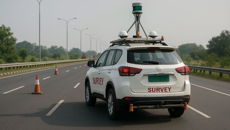
- Vehicles with advanced sensors will scan highways using:
- 3D laser-based systems to detect surface irregularities.
- GPS units for accurate location mapping.
- Inertial Measurement Units (IMUs) to measure acceleration and angular velocity.
- These systems will provide precise and real-time data on road conditions.
Data Collection and Monitoring
- Data will be gathered before and after highway construction, and every six months thereafter.
- It will cover all highway projects ranging from two-lane to eight-lane roads.
- Information will include pavement condition, cracks, and potholes to support preventive maintenance.
Centralised Data Analysis
- The collected data will be uploaded to NHAI’s AI-based ‘Data Lake’ portal.
- A specialised expert team will analyse the information to create actionable insights for:
- Asset management
- Maintenance planning
- Infrastructure upgrades
Additional Efforts by NHAI
- NHAI is identifying accident-prone black spots based on reports from State governments.
- Out of 13,795 black spots identified till March 2025, long-term corrective work has been completed on 5,036.
- The Electronic Detailed Accident Report (e-DAR) system is also being used to digitally record and monitor road accident data.
Significance
- Enhances road safety and driving comfort.
- Enables data-based decision-making for timely maintenance.
- Supports Government of India’s vision for smart, sustainable, and safe transport infrastructure.
This topic is available in detail on our main website.