A 6.7 magnitude earthquake recently struck Kirakira in the Solomon Islands, highlighting the region’s vulnerability to seismic activity — a geography topic often discussed in UPSC coaching in Hyderabad while preparing for GS1 world geography and disaster-related questions.
Location & Background
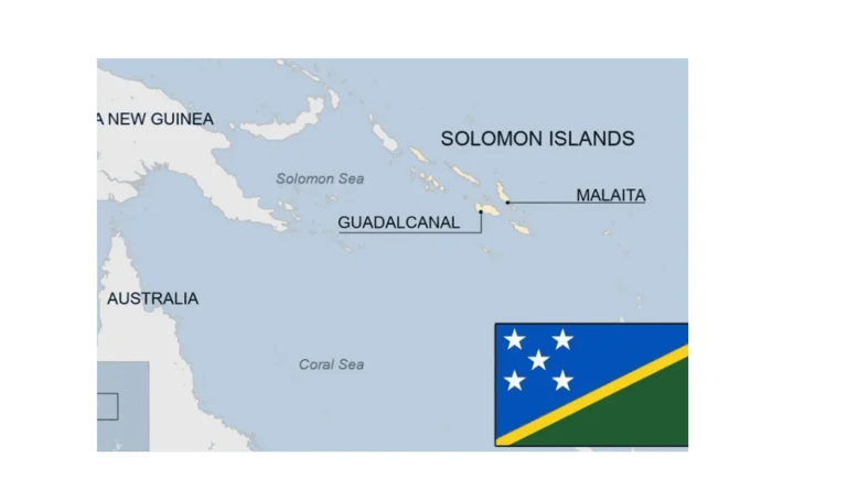
• Situated in the south-western Pacific Ocean.
• Comprises two parallel chains of volcanic islands along with several coral atolls.
• Lies southeast of Papua New Guinea and northwest of Vanuatu.
• Formerly a British protectorate, it became an independent republic in 1978.
• Capital: Honiara, located on Guadalcanal, the largest island.
• Government: Parliamentary democracy within the Commonwealth, with a unicameral legislature and ministerial system.
Geographical Features
• Nearly 1,000 islands in total — including 6 large islands and over 900 smaller ones.
• Around 147 islands are inhabited.
• Terrain: Mostly mountainous and forested, with some broad plains — features often analysed in IAS coaching in Hyderabad while studying Pacific island geography.
Demographics
Ethnic composition:
• Melanesian – 93%
• Polynesian – 4%
• Micronesian – 1.5%
• Others – 1.5%
Conclusion
The Solomon Islands’ vulnerability to earthquakes and other natural disasters, due to its location along the Pacific seismic belt, makes it geopolitically and environmentally significant. Understanding such regions is important for world geography preparation, often covered in UPSC online coaching and civils coaching in Hyderabad.
This topic is available in detail on our main website.